Mojini V3: Check Application Status, Login & View Sketch
Have you ever found yourself tangled in the complex web of land records, wishing there was a simpler way to verify boundaries or track a survey request? For many in Karnataka, the traditional process of managing land documents was once a journey through endless paperwork and multiple office visits. Enter Mojini V3, the Karnataka government’s sophisticated digital solution designed to put land record management directly into your hands.
Whether you are a farmer trying to protect your land, a real estate investor checking property details, or a homeowner wanting to see your property records online, Mojini V3 serves as the main platform for all these needs. This upgraded system does more than just move records online — it makes the entire process more transparent, faster, and easier to access from anywhere.
What is Mojini V3?
Mojini V3 is the newest version of Karnataka’s digital land survey and records management system, managed by the Department of Survey, Settlement, and Land Records (SSLR). Built on the strong Bhoomi platform, it works as the state’s upgraded system for managing and organizing land and spatial data more efficiently.
Key Features of Mojini V3
You can find the features the lives of Karnataka’s citizens:
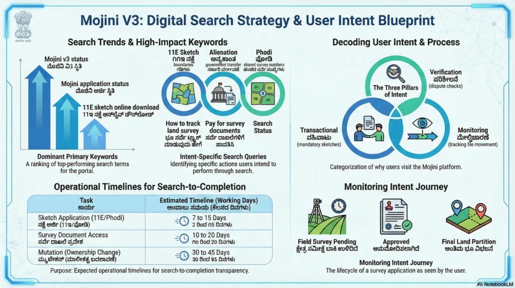
- Mojini Status Tracking: Real times updates of the land survey.
- Digital Sketches (11E & FMB): View and download maps and survey sketches online.
- Mobile & Web Accessibility: You can access through web portal and mobile application for Android.
- Integration with Bhoomi: It smoothly integrates with Record of Rights, Tenancy, and Crops (RTC) and mutation records, providing users with a single, unified system for accessing land information.
How to Check Mojini V3 Status
Through this portal check the status of your application. You cannot need to visit a government office.
Guide to Track Status:
- Visit to Official Portal: Visit to bhoomojini.karnataka.gov.in.
- Check “Application Status”: Open the “Application Status” or “Check Application Status” option.
- Choose Your Method: The portal offers three ways:
- Application Number: Enter the unique number provided during your request.
- Mobile Number: Use the registered mobile number linked to your application.
- Survey Number: Enter details including District, Taluk, Hobli, Village, and Survey/Hissa number.
- View Results: Check “Get Status” to see the status “Pending in Verification” or “Ready for Print”.
Understanding the 11E Sketch
The 11E sketch is an important document in Mojini V3. It is a pre-mutation survey sketch that is prepared when a part of agricultural land within a survey number is sold, gifted, or divided among owners.
Why it matters:
- It clearly shows the exact boundaries of the land that is being transferred.
- It helps avoid future legal disputes by defining accurate land measurements.
- It is required to complete the land registration and mutation process at the Sub-Registrar’s office.
You can see and download your approved 11E sketch from Mojini Portal once the survey is complete.
Mojini V3 Login and Registration
Almost services is available in public view, but some require a secure login.
- For Citizens: You can create account or use your registered mobile number or status check and document download.
- For Professionals: Licensed surveyors and government officials use the portal to upload survey data and handle application processing.
To log in, go to the official website and enter your username and password. You can also sign in using the Single Sign-On (SSO) ID if it is available. If you face any problems while logging in, you can contact the SSLR department help desk at 08022221038.
Benefits of Using Mojini V3
Mojini V3 offers different strategic advantages:
- Transparency: All step of survey process is viewable by applicant, reducing the opportunity for corruption.
- Speed: Digital processing and automated workflows greatly reduce the time needed for survey approvals.
- Cost-Effective: If you get status updates online, citizens save travel costs and document fees.
- Accurate Data: Digitized Akarband and spatial records help keep land data accurate and reduce the risk of manual changes or tampering.
Conclusion
Mojini V3 has completely changed the way land records are handled in Karnataka. Instead of old paper-based systems, the state now uses a real-time digital system that makes everything more transparent and easier to access. Whether you want to track a new survey application or download an important 11E sketch, the portal is a reliable tool for managing property records.